Automatisierte Ortung der Asiatischen Hornisse
mittels Radiotelemetrie
Localisation automatisée du Frelon asiatique
par radiotélémétrie
Automated Tracking of the Asian Hornet
via Radio Telemetry
Vespa velutina breitet sich seit 2017 in der Schweiz aus. Die invasive Art dezimiert einheimische Bienenvölker und ist schwer zu bekämpfen — weil ihre Nester oft erst spät und zufällig entdeckt werden. Herkömmliche Suchmethoden sind zeitaufwendig und unzuverlässig.
Vespa velutina se répand en Suisse depuis 2017. Cette espèce invasive décime les colonies d'abeilles indigènes et est difficile à combattre — car ses nids ne sont souvent découverts que tardivement et par hasard. Les méthodes de recherche conventionnelles sont chronophages et peu fiables.
The Asian Hornet (Vespa velutina) is spreading rapidly across Europe. It decimates bee colonies and threatens biodiversity. Finding nests manually is time-consuming and imprecise — tracking technology makes systematic control possible for the first time.
Ein einzelnes Nest kann täglich hunderte Bienen erbeuten und ganze Völker dezimieren.
Un seul nid peut capturer des centaines d'abeilles par jour et décimer des colonies entières.
A single nest can capture hundreds of bees per day and decimate entire colonies.
Nester befinden sich oft in Baumkronen. Manuelle Verfolgung ist zeitintensiv und ungenau.
Les nids se trouvent souvent dans les cimes des arbres. Le suivi manuel est laborieux et imprécis.
Nests are often located in treetops. Manual tracking is time-consuming and imprecise.
Je früher ein Nest lokalisiert und entfernt wird, desto geringer der ökologische Schaden.
Plus un nid est localisé et retiré tôt, plus les dommages écologiques sont limités.
The earlier a nest is located and removed, the lower the ecological damage.
HornetSentinel kombiniert miniaturisierte VHF-Transmitter an gefangenen Hornissen mit einem Netzwerk aus mehreren Empfangsstationen. Die Signale werden automatisch trianguliert — der Aufenthaltsort der markierten Hornisse erscheint in Echtzeit auf einer digitalen Karte.
HornetSentinel combine des émetteurs VHF miniaturisés sur des frelons capturés avec un réseau de plusieurs stations réceptrices. Les signaux sont triangulés automatiquement — la position du frelon marqué apparaît en temps réel sur une carte numérique.
HornetSentinel equips hornets with miniature VHF radio transmitters. Multiple KrakenSDR direction-finding stations triangulate the signal source in real time — the nest location appears on the map.
Gefangene Hornisse erhält einen 200–500 µW VHF-Transmitter (148 MHz)
Une frelon capturé reçoit un émetteur VHF 200–500 µW (148 MHz)
A captured hornet receives a 200–500 µW VHF transmitter (148 MHz)
Mehrere KrakenSDR-Stationen erfassen das Signal und berechnen den Einfallswinkel
Plusieurs stations KrakenSDR captent le signal et calculent l'angle d'arrivée
Multiple KrakenSDR stations receive the signal and calculate the angle of arrival
Der Server berechnet automatisch den Schnittpunkt aller Peillinien
Le serveur calcule automatiquement l'intersection de toutes les lignes de relèvement
The server automatically computes the intersection of all bearing lines
Position und Verlauf der Hornisse erscheinen live im Web-Portal
La position et la trajectoire du frelon s'affichent en direct dans le portail
The hornet's position and track appear live in the web portal
HornetSentinel basiert auf dem etablierten MUSIC-Algorithmus zur Richtungsbestimmung (Direction of Arrival, DOA) — ein Verfahren das in der Wildtiertelemetrie und professionellen Peilanlagen eingesetzt wird.
HornetSentinel repose sur l'algorithme MUSIC éprouvé pour la détermination de direction (Direction of Arrival, DOA) — une méthode utilisée en télémétrie faunistique et dans les installations de radiogoniométrie professionnelles.
HornetSentinel is based on the established MUSIC algorithm for direction of arrival (DOA) estimation — a method used in wildlife telemetry and professional radio direction-finding systems.
5-Kanal kohärenter SDR-Empfänger mit GPS und Kompass. Professionelle Richtungsbestimmung in Echtzeit.
Récepteur SDR cohérent 5 canaux avec GPS et boussole. Radiogoniométrie professionnelle en temps réel.
5-channel coherent SDR receiver with GPS and compass. Professional direction-finding in real time.
Multiple Signal Classification — hochauflösender DOA-Algorithmus, robust bei schwachen Signalen.
Multiple Signal Classification — algorithme DOA haute résolution, robuste sur signaux faibles.
Multiple Signal Classification — high-resolution DOA algorithm, robust under weak signals.
Echtzeit-Karte mit Peillinien, Schnittpunkten, Heatmap und Verlaufsanzeige. Swisstopo-Integration.
Carte temps réel avec lignes de relèvement, intersections, heatmap. Intégration Swisstopo.
Real-time map with bearing lines, intersections, heatmap and track display. Swisstopo integration.
Gesichertes Netzwerk zwischen allen Stationen und dem zentralen Portal. Zugriff ausschliesslich für autorisierte Nutzer.
Réseau sécurisé entre toutes les stations et le portail central. Accès exclusivement réservé aux utilisateurs autorisés.
Secured network between all stations and the central portal. Access restricted to authorised users only.
Sphärische Schnittpunktberechnung mit Konfidenzgewichtung. Automatische Kalibrierung.
Calcul d'intersection sphérique avec pondération de confiance. Calibration automatique.
Spherical intersection computation with confidence weighting. Automatic calibration.
Vollständig responsiv — Portal auf Smartphone, Tablet und Desktop nutzbar im Feld.
Entièrement responsive — portail utilisable sur smartphone, tablette et bureau sur le terrain.
Fully responsive — portal usable on smartphone, tablet and desktop in the field.
Integriertes Planungswerkzeug zur Vorab-Evaluation optimaler Stationsstandorte — Geometrie, Reichweite und Ortungsgenauigkeit simulierbar vor dem Feldeinsatz.
Outil de planification intégré pour évaluer à l'avance les positions optimales des stations — géométrie, portée et précision de localisation simulables avant l'opération terrain.
Integrated planning tool for pre-evaluation of optimal station positions — geometry, range and location accuracy simulatable before field deployment.
Das integrierte Simulationswerkzeug berechnet Peillinien, Kreuzpunkte und Ortungsgenauigkeit für beliebige Stationsaufstellungen — vor dem eigentlichen Feldeinsatz. Optimale Standorte werden automatisch vorgeschlagen.
L'outil de simulation intégré calcule les lignes de relèvement, les points d'intersection et la précision de localisation pour n'importe quelle configuration de stations — avant l'opération terrain. Les positions optimales sont suggérées automatiquement.
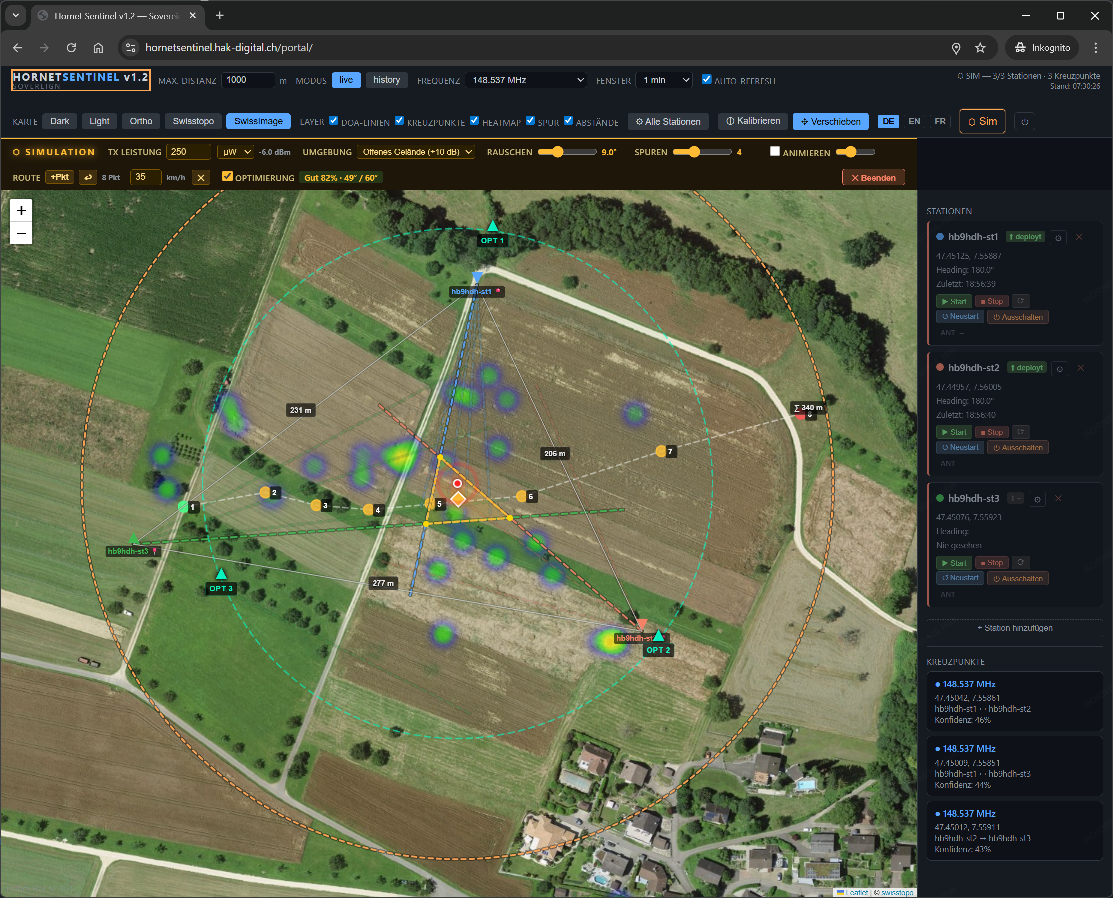
The integrated simulation tool calculates bearing lines, intersection points and location accuracy for any station arrangement — before the actual field deployment. Optimal positions are suggested automatically.
Simulation mit 3 Stationen · Peillinien · Kreuzpunkt-Heatmap · Fehlerpolygon · GDOP-Optimierung · Luftbild SwissImage
Simulation avec 3 stations · Lignes de relèvement · Heatmap d'intersection · Polygone d'erreur · Optimisation GDOP · Orthophoto SwissImage
Simulation with 3 stations · Bearing lines · Intersection heatmap · Error polygon · GDOP optimisation · SwissImage aerial photo
HornetSentinel befindet sich im Feldtest-Stadium in der Nordwestschweiz (BL/BS). Bei Interesse an einer Zusammenarbeit — ob für Monitoring, Pilotprojekte oder andere Anwendungen — freuen wir uns über eine Kontaktaufnahme.
HornetSentinel est en phase de tests terrain dans le nord-ouest de la Suisse (BL/BS). Pour tout intérêt de collaboration — monitoring, projets pilotes ou autres applications — n'hésitez pas à nous contacter.
HornetSentinel is in field-testing stage in north-west Switzerland (BL/BS). If you are interested in collaboration — for monitoring, pilot projects or other applications — we welcome your contact.